St. Louis Metropolitan Area
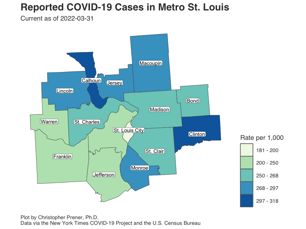
The following plots and maps focus on the St. Louis metropolitan statistical area, which covers fifteen counties in Missouri and Illinois.
Infections
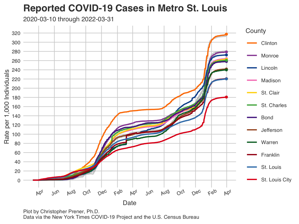
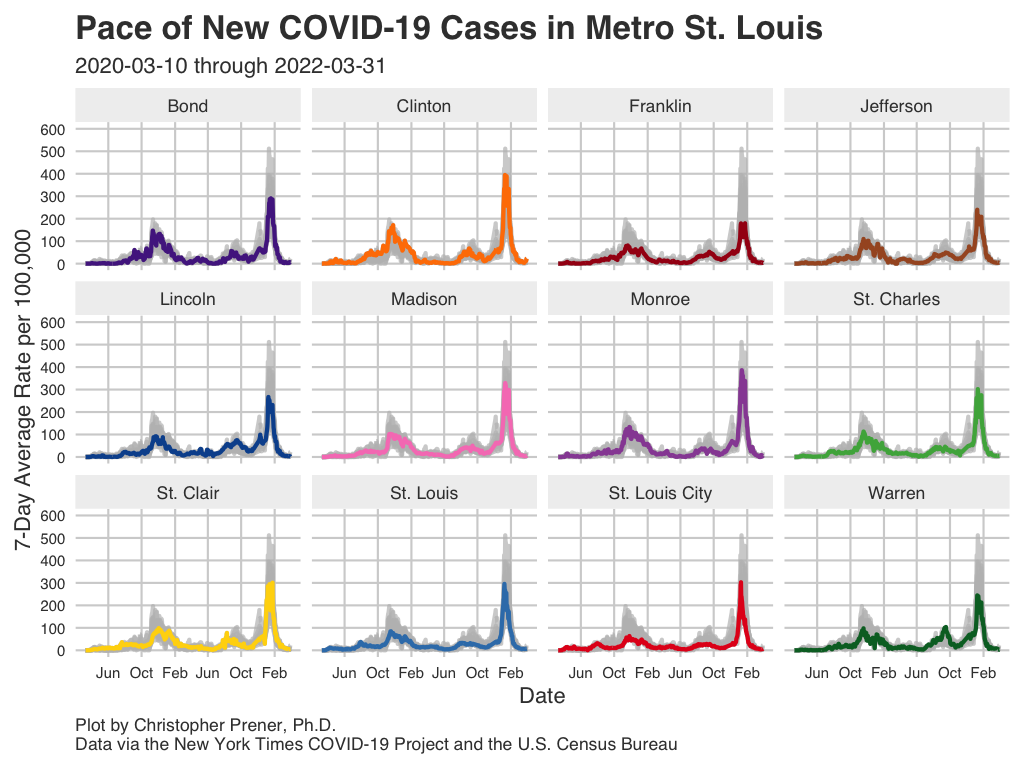
These plots show patterns in infections for counties within the St. Louis metro area.
Data Table
Notes
- The underlying data for these plots are available from GitHub in the
county_full.csvtable, which is assembled from data provided by the New York Times. - The FAQ contains short explanations of per-capita rates and log plots.
- All averages presented are 7-day rolling averages.
Mortality
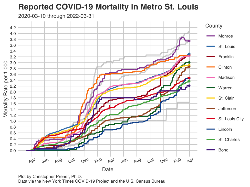
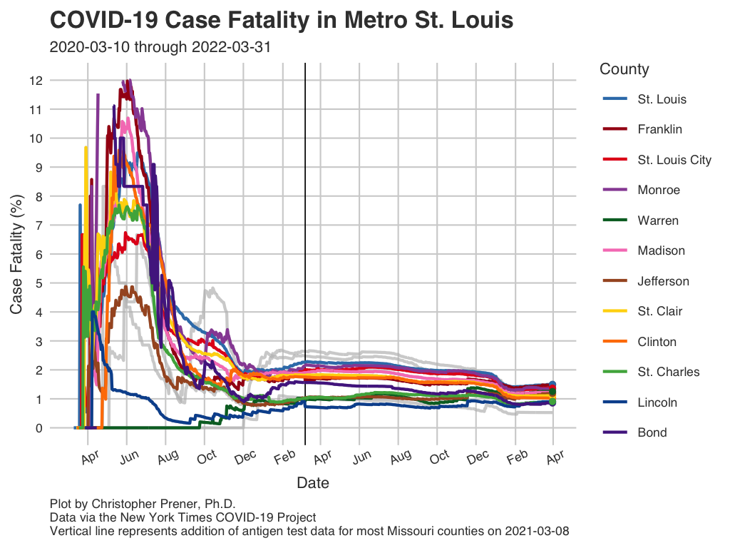
These plots show patterns in deaths for counties within the St. Louis metro area.
Data Table
Notes
- The underlying data for these plots are available from GitHub in the
county_full.csvtable, which is assembled from data provided by the New York Times. - The FAQ contains short explanations of per-capita rates and log plots.
- All averages presented are 7-day rolling averages.
- The abbreviation “CFR” states for case fatality rate (the number of deaths divided by the number of known cases, expressed as a percentage).
Infection Rates by ZCTA (Zip Code)
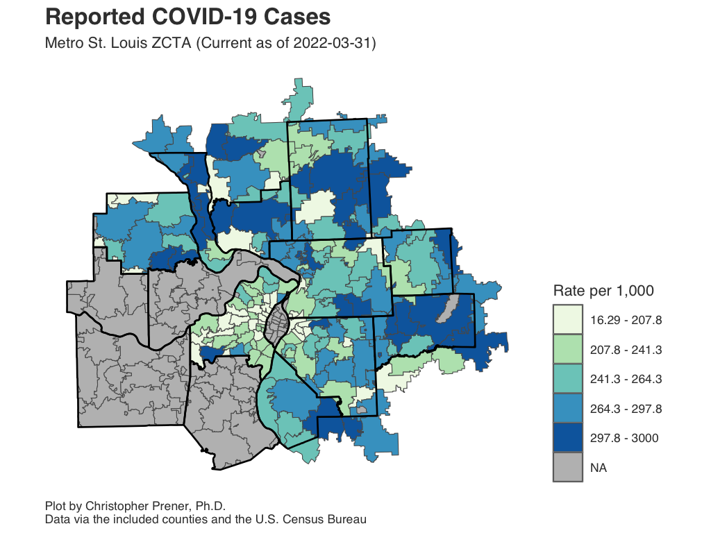
This map shows infections as a rate per 1,000 residents for all ZCTAs with five or more patients. It is important not to map the raw counts themselves, but if you want to see those data, click on a ZCTA or the data table.
Interactive Map
Data Table
Notes
- If a ZCTA straddles two counties, and only has reported infection numbers in one entity, its estimated partial population will be displayed. Similarly, estimated partial populations for zip codes that straddle outlying counties are used.
- ZCTA stands for “ZIP Code Tabulation Area. These are not identical to zip codes, but they are essential for mapping zip codes as regions on a map.
- The underlying data for these plots are available from GitHub in the following tables:
- Franklin County -
zip_franklin_county.csv - Jefferson County -
zip_jefferson_county.csv - Lincoln County -
zip_lincoln_county.csv - Metro East -
zip_metro_east.csv - St. Charles County -
zip_st_charles_county.csv - St. Louis City -
zip_stl_city.csv - St. Louis County -
zip_stl_county.csv - Warren County -
zip_warren_county.csv
- Franklin County -
- These data are also available as
.geojsonfiles for mapping. - These tables are assembled from data provided by local health departments in Missouri and the Illinois Department of Public Health.
- The FAQ contains a short explanation of per-capita rates.
Average New Infections by ZCTA (Zip Code)
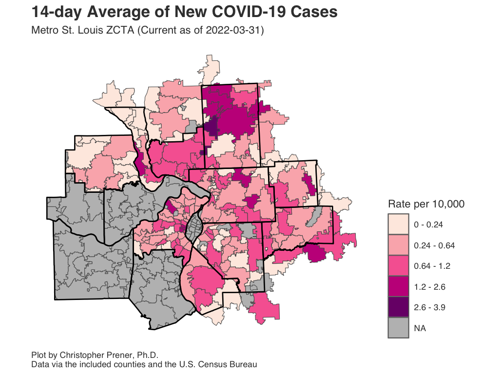
This map shows the 14-day average of new infections as a rate per 10,000 residents for all ZCTAs with five or more patients. It is important not to map the raw counts themselves, but if you want to see those data, click on a ZCTA or the data table.
Interactive Map
Data Table
Notes
- If a ZCTA straddles two counties, and only has reported infection numbers in one entity, its estimated partial population will be displayed. Similarly, estimated partial populations for zip codes that straddle outlying counties are used.
- ZCTA stands for “ZIP Code Tabulation Area. These are not identical to zip codes, but they are essential for mapping zip codes as regions on a map.
- The underlying data for these plots are available from GitHub in the
zip_stl_city.csvandzip_stl_county.csvtables, which are assembled from data provided by St. Louis City and County. These data are also available as.geojsonfiles for mapping. - The FAQ contains a short explanation of per-capita rates.
Hospitalizations
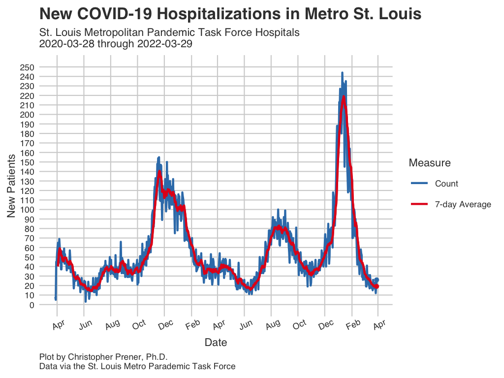
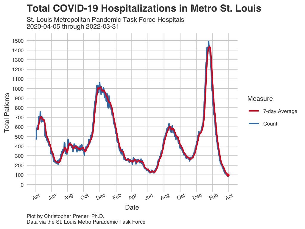
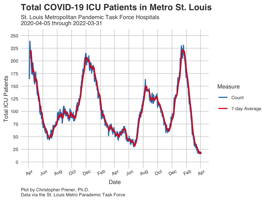
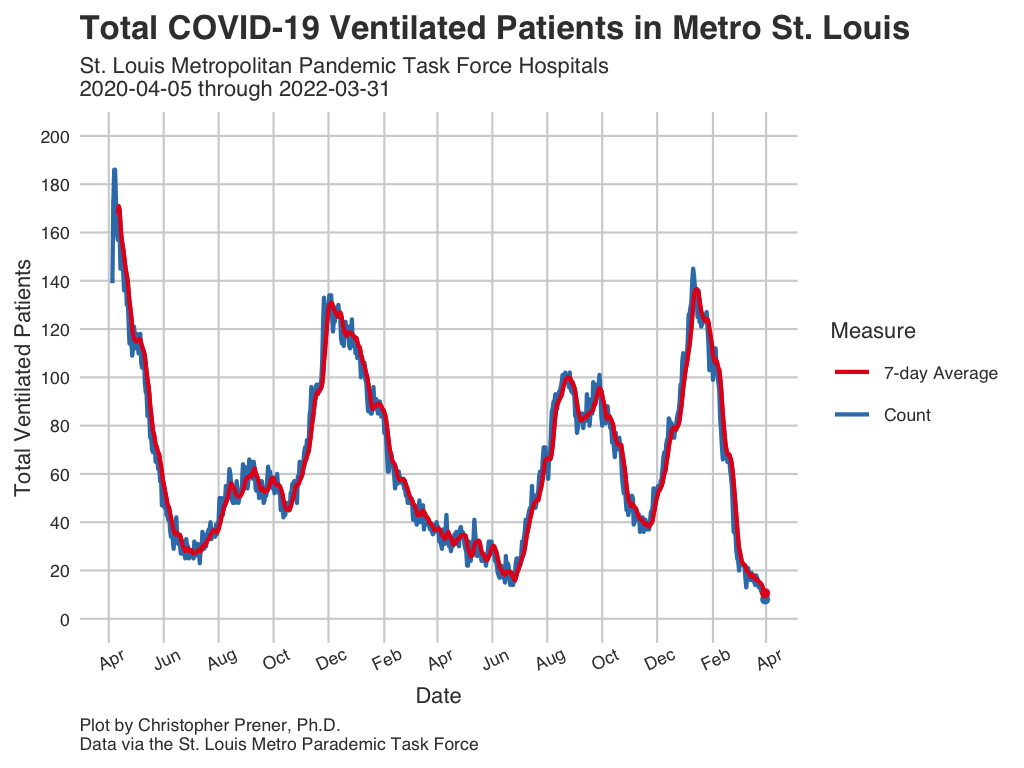
St. Louis has had a regional pandemic task force that covers four major health care systems: SSM (SLU), BJC Healthcare, Mercy, and St. Luke’s Hospital. The task force has been providing daily media briefings since April 5th. Their data covers the largest hospital systems in the region, so while it does not include every possible hospital, it does include a large share of COVID-19 patients. All averages presented are 7-day rolling averages.
In-Patient Metrics
Data Table
Notes
- The underlying data for these plots are available from GitHub in the
stl_hospital.csvtable, which is assembled from data provided by the St. Louis Pandemic Task Force. - All averages presented are 7-day rolling averages.
- The new in-patient measure is lagged two days behind its report day.
ICU Metrics
Data Table
Notes
- The underlying data for these plots are available from GitHub in the
stl_hospital.csvtable, which is assembled from data provided by the St. Louis Pandemic Task Force. - All averages presented are 7-day rolling averages.
Copyright © 2020-2021 Christopher Prener, Ph.D. All code, data, website content, and images are available under a Creative Commons Attribution 4.0 International License.
